Building a Satellite-Powered Crop Monitoring Platform with Laravel and Vue
Published on by Aleksandar Cvetanovski
Agriculture is rapidly evolving, and access to real-time data is becoming essential for better decision-making. In this project, I built a satellite-powered crop monitoring platform that allows users to track agricultural parcels and analyze crop health using vegetation indices like NDVI.
The Idea Behind the Project
Farmers and agricultural businesses often rely on manual field inspections or fragmented tools to monitor their crops. This process is time-consuming and inefficient.
The goal of this platform is simple:
- Provide real-time insights into crop health
- Reduce the need for physical inspections
- Enable smarter, data-driven decisions
By leveraging satellite imagery, we can monitor large areas of land with minimal effort.
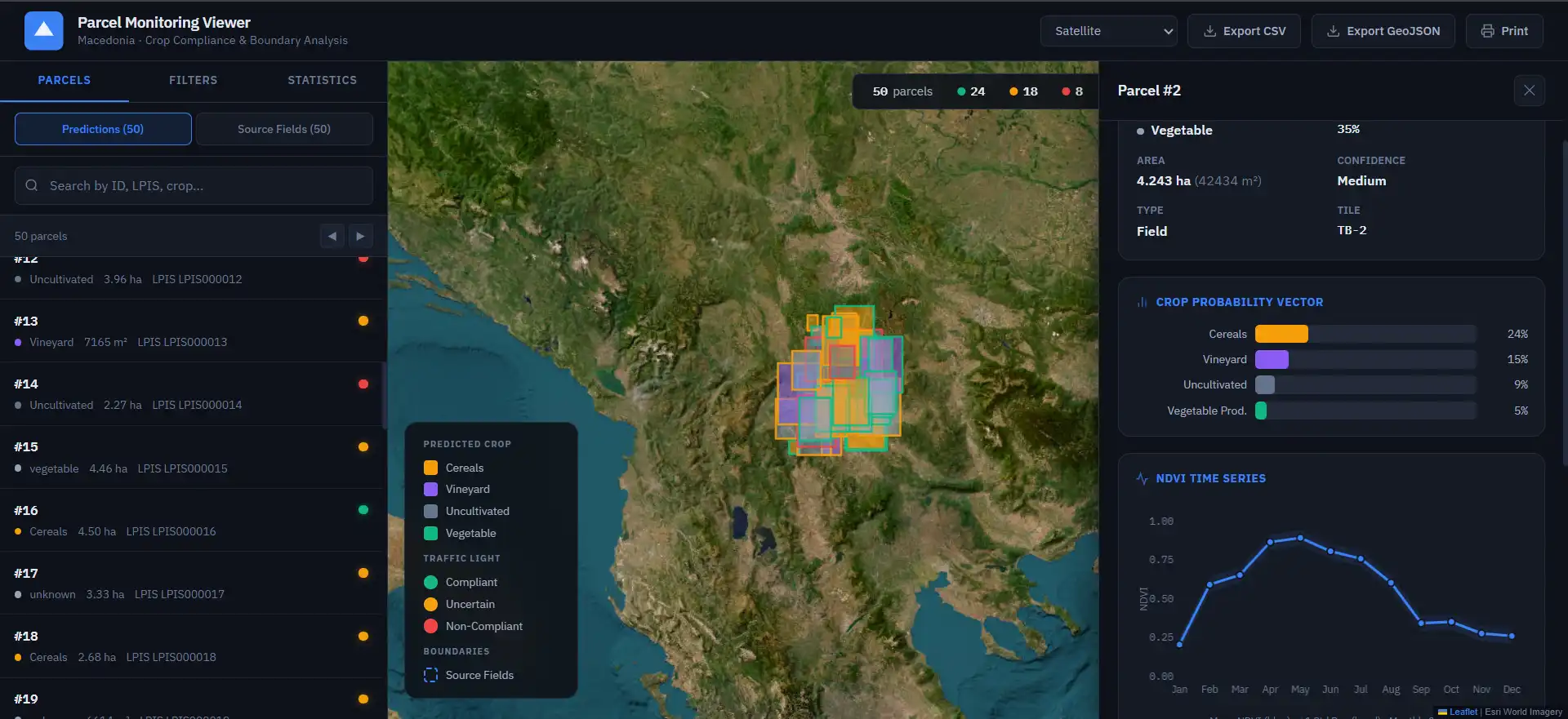
🌍 Parcel Management with Geospatial Data
Using PostgreSQL + PostGIS, parcels are stored as geometric shapes (polygons), allowing precise mapping and spatial queries.
🛰️ Satellite Data Integration
Satellite imagery is processed to extract meaningful agricultural insights.
🌱 NDVI Monitoring
NDVI (Normalized Difference Vegetation Index) is used to measure vegetation health and detect stress early.
📊 Time-Series Analysis
Track how crops evolve over time and identify trends or anomalies.
Tech Stack
This project uses a modern, scalable stack:
Backend
- PHP 8.4
- Laravel 13
Database
- PostgreSQL
- PostGIS (for geospatial queries, polygon storage, spatial indexing)
Frontend
- Vue 3
- Inertia.js
- Tailwind CSS 4
Tooling & Ecosystem
- Laravel Wayfinder, Boost, MCP, Pail
- PHPUnit
- Rector & Pint
- ESLint & Prettier
Why PostGIS Matters
Handling agricultural parcels without geospatial support is limiting.
With PostGIS, we can:
- Store parcel boundaries as polygons
- Run spatial queries (e.g., intersection, containment)
- Efficiently index and query large geographic datasets
- Integrate seamlessly with mapping libraries
This makes the platform scalable and production-ready for real-world agricultural use.
Use Cases
- Precision agriculture
- Crop health monitoring
- Yield optimization
- Agricultural analytics platforms
What’s Next
Future improvements include:
- AI-based crop predictions
- Weather data integration
- Smart alerts for crop stress
- Mobile-first experience
This project is a step toward building smarter, more efficient farming tools powered by modern web technologies.